Grad Student Plays Role in CI Effort Readying Coastal Communities for Chronic Flooding
Helping communities meet environmental challenges – it’s been the focus of Patrick MacMeekin’s professional life, and the reason why he found a University of Rhode Island (URI) Coastal Institute (CI) demonstration project so compelling.
“Forest environments, especially concerning fires, were my focus out West – so I definitely have an interest in working with places on their environmental issues,” says MacMeekin, a URI College of the Environment and Life Sciences (CELS) graduate student pursuing a Master of Environmental Science and Management (MESM) degree. “So yes, I’ve gone from fire to water, but my overall thought is still the same: help communities address those environmental problems that pose risks.”
And the CI gave MacMeekin the perfect opportunity to do so, with its ongoing initiative providing science-informed technical assistance to local coastal communities facing the challenges of flooding, a climate change impact tied to strong storms and sea level rise.
The CI’s Climate Response Demonstration Sites Project is a multi-year effort engaging several Rhode Island coastal municipalities, including Barrington, Warren, Providence, and Westerly. Through this program, the CI funds research and outreach activities to evaluate varied climate change adaptation practices and show and share resiliency responses. Participating communities – including municipal leaders, planning staff, businesses, and land managers – partner with URI experts to learn about the latest climate change science, test out new planning tools, like mapping programs, monitor local impacts of climate change, and collaborate with peers undertaking similar work. The CI demonstration sites reflect a span of development – natural, urban, and mixed-use – and feature obstacles that can hamper local ability to protect people and property from common climate change impacts, including exacerbated flooding and erosion.
The project, which CI supports with a mixture of funds – including those from a range of partners, is a win-win situation, providing technical assistance to coastal communities facing climate challenges, and practical, real-life experience to URI graduate students honing workforce skills. “We are supporting the municipalities with the science and assistance they need to start planning for coastal flooding,” says CI Assistant Director Nathan Vinhateiro. “At the same time, we’re actively supporting student education, and preparing them for future careers.”
In MacMeekin’s case, his knowledge and skills in the environmental arena – he worked as a forester with a state agency while on the West Coast – have grown via his graduate studies and the paid MESM opportunity with the CI and the demonstration project. “It’s really been rewarding to be able to focus on the GIS or mapping aspect of the project,” he says. “Communities facing flooding very much need this kind of information.”
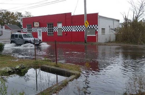
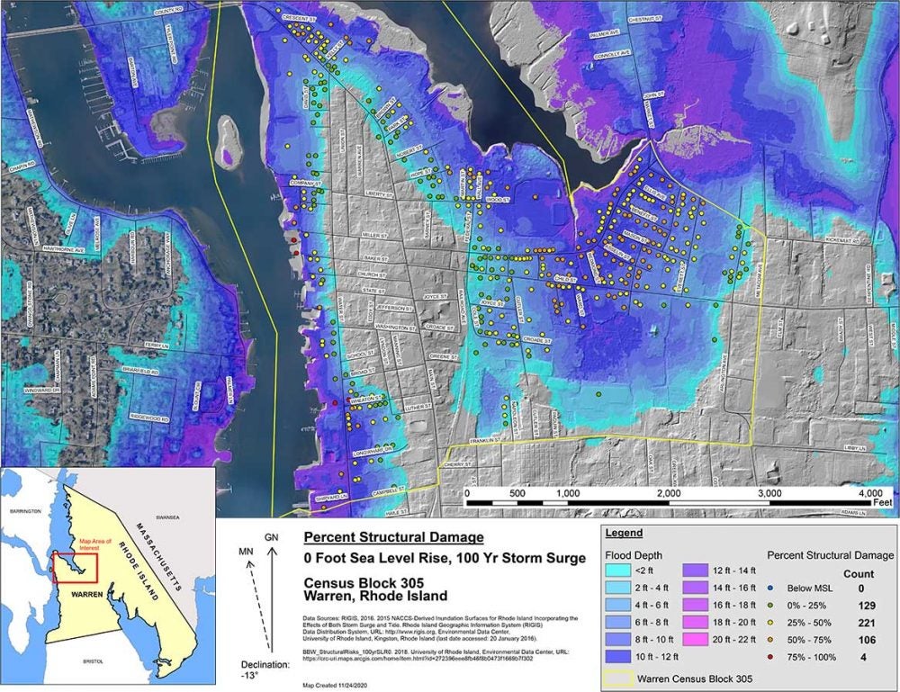
The Town of Warren serves as a “mixed-use” demonstration site for the project, with MacMeekin putting his mapping expertise to work; the data and visual analysis he has provided is now part of Warren’s resilience toolkit. Warren, with a significant amount of its East Bay coastline either at or a little below sea level, is actively preparing for rising water; its commercial district is proximate to Narragansett Bay and roadway flooding is an increasing concern. The particular information that MacMeekin provided will help address flooding in the low-lying area adjacent to Belcher’s Cove, and helps Warren understand potential impacts to the town’s roadway network and residential housing.
Bob Rulli, director of Warren’s Office of Planning and Community Development, indicates that collaborative efforts, such as the CI project, are vital parts of the overall process to solve the problem. “Patrick created over 100 maps for us,” says Rulli. “They show the measured impacts of sea level rise and flooding in feet and inches, as well as structural damage scenarios, evacuation route vulnerability, and potential tax revenue loss due to flooding.” And the work stands to be useful for building further support for resilience efforts in Warren. “We’re hoping that with his work product we can inform not just our elected leaders, but also insurers and lenders, to help them all make more informed decisions moving forward.”
For MacMeekin, who moved East with his wife, Dr. Melva Treviño Peña, so she could join the URI Marine Affairs department as an Assistant Professor – he started his own such studies soon after – graduation approaches, but the valuable experience gained through his time with the CI program remains. “Great, great experience, and one which I would recommend to others,” he says. “It has made me even more committed to these issues of helping communities work through their environmental problems.”
Interested in playing a part at CI like Patrick did? Contact the CI at (401) 874-6513 or send an email to coastalinstitute@etal.uri.edu.