“The people shall continue to enjoy and freely exercise all the rights of fishery, and the privileges of the shore, to which they have been heretofore entitled under the charter and usages of this state, including but not limited to fishing from the shore, the gathering of seaweed, leaving the shore to swim in the sea and passage along the shore;”
Rhode Island State Constitution –Article 1, Section 17
 Rhode Island is one of the most densely populated coastal zones in the country, with 90 percent of the state’s residents living within a 20-minute drive of the shoreline. Accordingly, public access to the shoreline is an important coastal resource for all Rhode Islanders. In fact, this public trust doctrine is codified in the state constitution, which gives all residents the right to access the shoreline for fishing, recreation, and other privileges.
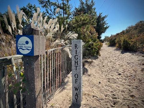
Access to the coast is provided at over 225 state-designated rights-of-way (ROW) and at hundreds of other points that are either owned by federal, state, or municipal government and managed for the public, or owned by private organizations who welcome the public. These sites range from footpaths to fishing piers, allowing residents and visitors to the state to use the coastline and engage in ocean activities. In Rhode Island, the public also has the right to lateral (alongshore) access for the entirety of the state’s 400 miles of shoreline below mean high tide. However, the continued enjoyment of these public space is increasingly threatened by climate change, coastal development, and the actions of property owners to limit access. The issue is further complicated by restrictions on parking, signage, and other local ordinances.
Through its Climate Response Demonstration Site program, the Coastal Institute is supporting several new monitoring and outreach projects to enhance and protect the public’s access to the shore and provide policymakers with up to date science and information about coastal processes. Diversity, Equity, and Inclusion is an important motivator for this work, as limitations on coastal access often target minority communities and non-native English speakers. This includes both field and desktop projects to update and enhance the state’s ROW database, identify sites where climate change will impinge on public trust lands, and develop tools and outreach products that safeguard access for Rhode Islanders now and into the future.
Resources:
Pocket guide to Rhode Island’s rights-of-way to the shoreline [Brochure]
Interactive map of state-designated rights-of-way to the RI shoreline
Rhode Island’s shoreline is public land [Factsheet]
Tidal datums can’t be seen on the shore [Infographic]